 Location: Bo Thong Lang sub-district, Bang Saphan district.
How to go: Ues highway 4 (Phetchakasem Road) from Thap Sakae district drive along southward to Bang Saphan district until km marker 379, turn left into Bang Saphan district.
Take highway 3169 and crossroads into Klang Ao Road go along the beach road until find the Entrance of Bo Thong Lang Bay.
Season: All year
The scenery and sample place of Mae Ramphueng Beach-Bo Thong Lang Bay, Prachuab Khiri Khan Province
The quiets atmosphere of Mae Ramphueng Beach.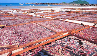
The products of the sea of fisherman village at Mae Ramphueng Beach.
Bo Thong Lang Beach is not far from Ban Krud Beach, this is the beauty small and good to swim.
 Location: Puek Tien sub-district,Tha Yang district, about 22 km from Phetchaburi Town.
How to go: From Phetchaburi Town, use Rajadamri Road and turn left into the highway 3177 passing the Rajabhat Institute of Phetchaburi for about 13 km, at the junction go Straight onto Chao Sam Ran Beach.
Then turn right onto the beach road for 7 km.
Season: All year
The scenery and sample place of Puek Tien Beach, Phetchaburi Province
Fisherman village at Puek Tien Beach.
Horse ridding around Puek Tien Beach.
The sculptures of the characters in Apaimanee Literature most attracting one in the sea front of Puek Tien Beach.
The giantess sculpture on the beach is the signature of thia beach.
 Location: Ban Bang Berd, Sai Thong sub-district, Bang Saphan Noi district.
How to go: Ues highway 4 (Phetchakasem Road) until km marker 425, go crossroad into highway 3479 for about 16 km head on the beach.
Season: All year
The scenery and sample place of Bang Berd Beach, Prachuab Khiri Khan Province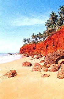
Pha Daeng, the behide the sea you can walk to Bang Berd Beach.
Bang Berd Beach, the last beach of Prachuab Khiri nestled near Tham Thong Beach of Chumphon.
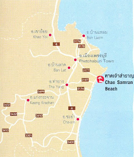 Location: Beach sub-district, Muang district, About 15 km from Phetchaburi Town.
How to go: Phetchaburi Town, use Rajadamri Road and turn left into the highway 3177 passing the Rajabhat Institute of Phetchaburi for about 13 km, at the junction go Straight onto Chao Samran Beach.
Season: All year
The scenery and sample place of Chao Samran Beach, Phetchaburi Province
The fantastically pine tree of Chao Samran Beach.
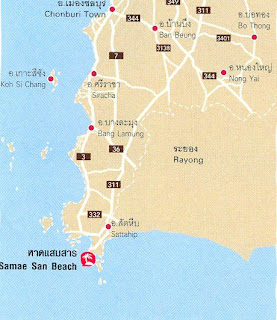 Location: Samae San Villages, Samae San Sub-district, 14 km from Sattahip district.
How to go: From Sukhumvit Road drive along the direction to Rayong until find garden and King Rama 6 monument, go straight just few Distance head on Samae San Villages or take By pass around 10 km pass Sirikit Hospital, you will find Samae San Villages.
Season: All year
The scenery and sample place of Samae San Beach, Chonburi Province
The pier of Samae San Village.
Luang por Dum Temple is locate on Khao Chedi.

The scenery of Koh Rad looking from Luang Por Dum Temple.
 Location: Within Sattahip Naval Base
How to go: From Sukhumvit Road drive along the direction to Rayong, you will find the direction to Sattahip Naval Base and turn right to contact at military area.
Finally, go straight on until find the beach.
Season: All year
The scenery and sample place of Toey Ngam Beach (Haad Navikayothin), Chonburi Province
The Royal Thai Navy at Toey Ngam Beach.
The Royal Navy Officer.
Toey Ngam Beach is stretches almost 2 kilometers and pretty safe for swimming.
The Navy Monument at Toey Ngam Beach.
 Location: Within Navy Station, far from Chuk Samed Buck around 1km.
How to go: From Sukhumvit Road drive along the direction to Rayong until find junction,turn right for 2 km to highway 3126.
Then turn right about 5 km and turn left at military area for 1 km head on the beach
Season: All year
The scenery and sample place of Nang Ram-Nang Rong Beach, Chonburi Province
Tenting site at Nang Rong Beach.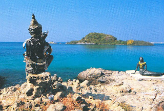
The sculpture of the famous character in Thai Literature named Phra Apaimanee at Nang Ram Beach.
The white sandy beach and the clear Water of Nang Ram Beach.
Nang Rong Beach is next from Nang Ram Beach, You can see the island at the front of this beach.
 Location: Nong Prue sub-district,Bang Lamung district.
How to go: From Bangkok, take Motor Way (Bangkok- Chonburi).
Then take highway Sukhumvit pass Si Racha, Bang Lamung district And pattaya until km marker 150,turn to Na Jomtien Beach route.
You will reached the Dong Tarn Beach on the right side.
Season: All year
The scenery and sample place of Dong Tarn Beach, Chonburi Province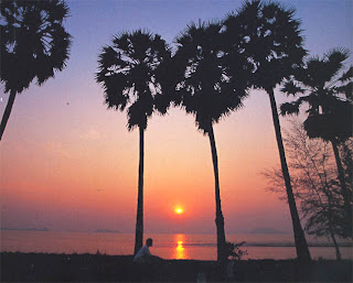
The sunset viewpoint at Dong Tan Beach.
 Location: Hua Hin sub-district, Hua Hin district.
How to go: From Prachuab Khiri Khan town, take highway 4 passing Cha-Am Beach to Hua Hin district.
At km marker 232, there is a road on the left onto Damnoenkasem Road leading to the beach.
lf coming by train, get off at Hua Hin Station.
Season: All year
The scenery and sample place of Hua Hin Beach, Prachuab Khiri Khan Province
Baan Talay Dao Resort, Hua Hin.
Chomview Hua Hin Hotel.
Hua Hin Beach has still maintained incomparably classic story in the present.
 Location: Laem Pak Beai sub-district, Ban Laem district.
How to go: From Phetchaburi Town, use Rajadamri Road and turn left into the highway 3177 passing the Rajabhat Institute of Phetchaburi for about 13 km, at the junction go Straight onto Chao Samran Beach.
Then turn left and go straight to the beach.
Season: All year
The scenery and sample place of Laem Luang Beach, Phetchaburi Province
The first sand of the Gulf of begin from Laem Luang Beach in Phetchaburi. This is the bountiful mangrove forest of Thailand.
 Location: Bang Sa Re sub-district.
How to go: From Chonburi,drive along Sukhumvit Rond pass Suan Nong Nooch about 50 m, there are right turn to Bang Sa Re.
Then go straight on until reaching Wat Samakkhi Baanpod, turn right to get the beach.
Season: All year
The scenery and sample place of Bang Sa Re Beach, Chonburi Province
Bang Sa Re Beach is next from Jomtien Beach. Here is the road along the peaceful beach and delicious seafood restaurant.
 Location: Nong Preu sub-district,Bang Lamung district far from South Pattaya round 3 km.
How to go: From Bangkok,take Motor Way (Bangkok-Chonburi Road), then drive along Sukhumvit Road pass Si Racha, Bang Lamung district and pattaya until km marker 150, turn right to route Na jomtien beach.
Season: All year
The scenery and sample place of Na Jomtien Beach, Chonburi Province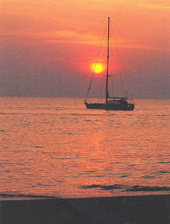
The sunset viewpoint looking from jomtien Baech.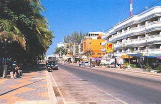
A lot of restaurants and hotels on the beach road of pattaya.
Jomtien Beach is much more peaceful than Pattaya Beach. It is another interesting choice for those who want more privacy.


